Wednesday, February 10, 2010

Observation Hill

One Wednesday night, post-science lecture, a few of us decided to take advantage of the relative calm and sunshine and climb Observation Hill. The hike up, while steep, was surprisingly easy and the summit offers a view of all of McMurdo Sound out to the sea ice edge. In the picture above, myself, Elise and Barb near the summit. Below shows the view back to McMurdo - a mere toy town from the height!
Also at the summit is Scott's cross to commemorate Scott and his three other companions who died in their effort to reach the South Pole.
Also note in both of the pictures over the sound the amount of open water. Word is that the sea ice has not cleared out to this extent in several years. This is nothing, however, compared to the times of Scott's expeditions in the area, when the Sound must have been open enough to land a ship at Hut Point on Ross Island - the island on which McMurdo was constructed.

Tuesday, January 12, 2010

PENGUINS!

Despite this being my fourth trip to Antarctica, I had yet to see a penguin. Lots of signs of them whilst at Palmer and mummified ones (+ footprints!) in the Dry Valleys last year, but not a single one in the flesh. So when rumors started circulating that some penguins had been seen out at Hut Point, my friend Amy and I went on Penguin Patrol.

The first time was a false alarm.

The second time at almost midnight, we headed out again and got to see a dozen or so Adelie penguins hanging out on the ice right next to the peninsula.


Adelies on the sea ice next to Hut Point

The one standing appeared to be on "watch" while the others were generally lazy. I think it was their bedtime. The little guy on watch was pacing back and forth, keeping an eye on the open water close by-- where a seal was swimming.


Adelies sleeping and standing guard

While they weren't particularly active, it was nice to see.

The next day, a group of us went out to see the Emperor penguins that were huddled on the road out to the Pegasus runway (where the fixed wing and continental flights go in and out). There were only four of them, but these penguins are the BIG guys so far as penguins go.


Emperors out on the permanent snow road to Pegasus

The one on the left in the photo above must have been cold to tuck his head away so well. It was slightly disconcerting to first see it like that. We almost thought that they were staged, stuffed penguins because they weren't moving and the one didn't have a head. But after a while, they started to move around a little bit. And the head reappeared.


LTER girls (Kelly, Amy, and Alyssa) with the penguins


"Beakers" having fun! (Our hands are supposed to be beakers)

Sunday, January 10, 2010

Mt. Terror vs. Scott Base Rugby

One of the highlights of a summer on the Ice is the annual game of rugby played between Scott Base (New Zealand) and McMurdo (USA). As expected, New Zealand has the advantage in these games since most of their participants have been playing since they were young. In contrast, the American team is generally formed in October by volunteers who have to essentially learn it all every year.


Penalty throw in technique

Last year, a good friend of mine played for the Mt. Terror Rugby Club (the intimidating name bestowed upon the McMurdo team). During the course of the game, he dislocated his shoulder. Despite the American inexperience with the game, they do go all out during play.


Pre-game national anthems and handshakes

On January 11, 2010 the game was played out on the rugby pitch -- a patch of groomed snow with crossbars out on the permanent ice with Mt. Erebus as a backdrop. It was a well-fought match, and in the end Scott Base prevailed with a score 23-nil.


It might also be worth it to mention that in the 26 years that the competition has been going on, Mt. Terror (USA) has never scored even a single point.

Maybe next year!

Tuesday, January 5, 2010

Discovery Hut

Recently, I tagged along with a group to Discovery Hut out on Hut Point within walking distance of McMurdo. It was prefabricated in warmer climates (Australia) and sent south on Robert Falcon Scott's Discovery Expedition.
From the Hut Point peninsula looking back at Discovery Hut (foreground) and McMurdo (background)


Meant to be living quarters for the crew, the Hut proved to be inadequate to house the men due to it's drafty nature. Thus the crew lived in the ship that brought them down and the hut was used for storage and cooking.

The hut was used as a base for several other expedition that came through (including several attempts at the South Pole) used it as a storage base up until 1917. It was "rediscovered" in 1956 by Americans who dug it out of the snow and ice.

The Hut has been returned to the conditions it was in after the Discovery Expedition -- including meat, stoves, clothing, and food stores. It's a piece of history right at our backdoor at the bottom of the world.
Yo Chin, a professor at OSU, acting as our tour guide inside Discovery Hut


Cooking area


Food and fuel stores


Seal meat


Vintage pants of the era...

Saturday, January 2, 2010

Christmas Celebration at Lake Hoare

The jaunt out into the Taylor Valley mentioned here, happened to be over the Christmas weekend. In Lake Hoare fashion, there was much celebrating: cookies, gingerbread houses, Christmas tree, and a gigantic dinner with good company to boot.
Luigi decorating cookies


Gingerbread house under construction


Gingerbread house with a candle inside after the shutters were closed.

We closed the shutters in the hut right before dinner, creating a "night" for Christmas. It was certainly different being in almost complete darkness out at Lake Hoare during the summer.


Tuesday, December 29, 2009

Upland Ponds: Before and After

While I am based mostly out of McMurdo Station this year, I did make it out into the Dry Valleys for a couple of days to help with some reconnaissance on the upland ponds area.

Last year was a much warmer year than this year. When I was in the uplands last year, the ponds were very easy to spot.

This year snow stuck to the ground and is completely obscuring the ponds!


It's interesting to see how things change!

Thursday, November 5, 2009

Mentally iced

Since my last post, I've been working on my research!

.... at least, I've been trying to get through the analytical portion of it before I leave for the Ice in December. Instrumentation troubles and distraction about, however. But such is science.

While I wait for the XRF (x-ray fluorescence) analyzer to be back up and running, I've been tasked by my advisor with a new dusty adventure. This time looking at soil profiles in Panama and seeing if there is any Saharan dust influence seen in the geochemical profile compared to bedrock. I'm still in the literature search stage, but it could prove interesting!

Unfortunately, my brain is already on the Ice. I'm working through the logistics of what I need to bring and what needs to happen before I go go go. This year, I'll be running a total organic carbon organizer instead of collecting samples, so I'll be in McMurdo more. We have a few sampling trips out to the Dry Valleys planned.


I'm excited!

Friday, August 28, 2009

Good news comes in high profile packages sometimes


About this time last year, my advisor told me that he thought I would be a good candidate for the NSF Graduate Research Fellowship Program. The program provides stipend funding and tuition waivers for it's recipients.

In early April, I was notified that I had received the fellowship.

What's more, with the stimulus package that the NSF received from President Obama, they were able to award ~200 more fellowships than their usual ~900. In the second round, another from the School of Earth Sciences at OSU was chosen as well. The picture (above) shows Annette and I with the president of the university, Gordon Gee, at an undergraduate research forum earlier this year. Gee appears to have a photographic memory: I have seen him since and he remembers both my name and the fact that I received "the NSF."

Wednesday, August 5, 2009

Back in Action

It's been a while!

School hit me hard with full-to-bursting class loads and working on the research I'm here to do, but I have created a bit of time and have a few updates. Starting with this one!

On Monday, August 3rd, Thompson Library opened it's doors for the first time since I have been a student at Ohio State. This building is one of the major presences on the south oval (the major greenspace on campus), but has been being renovated. The inside is now six floors of quiet, bookish heaven. I'm looking forward to making ample use of it once classes start up in the fall!

Thursday, January 29, 2009

Sledding

We had another ice-and-snow storm blow through. This is certainly an introduction to a northern winter. Apparently, it usually doesn't get like this until the end of February.

I experienced my first snow day yesterday. Ironically, the class I missed was glaciology. I still had to be on campus to run samples and attempt to catch up on some work, but my productivity was severely truncated by an introduction to the northern art of sledding. Also known as a practical experience in snow compaction.


I also made my third snow angel. Certainly in the most snow.

It was a nice change to the general weekday routine. I went out with a bunch of people later in the evening and sledded in a man-made ravine. I have the bruises to prove it, too.

Saturday, January 17, 2009

Wintry Ways

We had our first big snowstorm since I've been back from the Ice. About four inches fell over the course of one day last week. Most of it piled up on my car, and I got my first crash course in winter driving.

Luckily, the Subaru is an ideal car for such conditions.

The temperatures have been far below freezing for the last couple of days. Thursday and Friday the highs were maxing out at about 10oF/-12oC.


I still haven't found a winter coat, but that will be happening shortly. Those bitterly cold days were a bit of a stretch for this Florida girl, even with the sheer number of layers I managed.

School started, as well. Glaciology is a bit of a bear simply because of all the work involved. Paleoclimate will be picking up in the work-respect soon. They are both absolutely fascinating. There is also a lot of conceptual material overlap, which makes it even better. Same goes with my Carbon and Climate class. It's nice to be back to a routine.

Wednesday, December 24, 2008

Leaving the Ice

After leaving the Valleys, I had some time to kill in McMurdo. While dealing with drying out my samples, an ordeal that was more complicated than it sounds, I also did some walking. My friend, Nick (one of the firefighters), got a page about the possibility of penguins out at Hut Point. By the time we got there, the penguins had moved on but there were a couple of lethargic seals laying on the sea ice.

Even here, you can see the sea ice is starting to change. Since here, the powers that be in McMurdo have closed the roads out on the sea ice and progressively moved operations back to the margin with the Ross Ice Shelf.

I was supposed to leave the ice on December 16, but the flight was delayed in Christchurch. At 3:30AM on December 17, we were transported out to the Pegasus sea ice runway to catch our flight off -- a South African C100, which made for quite the ride. Cramped seats, leaking pipes, windows and all. All told, it took about 7 hours and we cleared customs faster than I ever have, with the exception of coming back from the Bahamas.


Flowing Water in the DRY Valleys

Kathy and I took a trip up to the Wright Valley on December 10 in another search for windblown sediments. We set down near the Stream Team's gauging station for the Onyx River. The Onyx is the longest river in Antarctica. It actually flows away from the coast, as there is a glacier blocking the exit. The glacier forms Lake Brownworth, which in turn feeds the Onyx.


We had five hours of ground time, so we spent it hiking in a big loop from the Onyx east to Lake Brownworth on the south side of the valley and back on the north side. We came across some pretty impressive windblown formations against the lee side of the hill slopes. There were also some pretty impressive ventifacts in the area, which I also sampled.


After talking to the Limno Team about their bundt pan experiments, it was decided that I would be the one to collect them this year. In doing so, I also get direct access to the samples. I was emailed a series of coordinates for each of the three transects of 9 pans: one at each of the major lakes in the Taylor valley (Fryxell, Hoare, & Bonney).

On my first run, Lake Fryxell transect by the F6 camp, two of the nine coordinates I was given were incorrect and one of the bundt pans set ups and been completely torn apart by the wind.
The transect at Lake Hoare went swimmingly. Lake Bonney, however, had it's own trials.

At Lake Bonney, technology failed me. Both my in-use batteries and the back-up batteries for my GPS died by the time I got to the fifth (of nine, again) bundt pan. I attempted to find the rest by line-of-sight and was successful, except for the ninth pan. In the end I had to call it lost because I was cutting it close on time to make it back to Lake Bonney in time for my helo flight back to Lake Hoare.


By the time I started hunting for bundt pans (and really from the time I went to Bonney the first time...) the moats on the lakes had started to open up in earnest. This makes crossing the lakes a very treacherous and, more often than not, a wet one. There's nothing quite as surprising as stepping on what appears to be solid ice, only to fall through and be wet above your boots in icey, glacier-fed lake water. There are even waterfalls coming off the glaciers!

It is around this time of year that the boats come out to get to the solid ice for those that find themselves needing to cross the lakes. It is also this time of year that the ATVs are no longer used, making lake walking take even longer.

Hoare crystals form along the margins of the thicker ice and where the lakes and the glaciers meet. These appear to be a function of the melting and refreezing of these relatively shallow portions of the water


Sunday, December 7, 2008

Lake Bonney Extravaganza


December 1-4, Sandra (Lake Hoare's assistant camp manager) and I headed upvalley into the Lake Bonney basin. We dropped our sleepkits off at the camp itself, and got a ride back to the Marr Glacier and Upland Ponds area to sample. (Above left, the Marr and a pond; above right Bonney basin; left, Taylor glacier and a ventifact)

The area is very picturesque. The Marr feeds five ponds in an upland plateau that then drain down into the Hoare basin.

As we continued out of the upland area into the Bonney basin proper, we started encountering large-scale ventifacts that are a stark reminder of the power of the winds that whip through the valleys. The ventifacts are formed when the strong winds blow sediment and abraid away parts of the rocks. If enough of a catchment is formed, sediments can get caught inside and blown around to create bowls and other hollows.

On the second day, we headed out onto the lake itself. Lake Bonney is divided into two lobes
divided by the Bonney Riegel, which creates a "Narrows" separating the lobes (see left).

The western lobe terminates (or, technically, is fed by) the Taylor Glacier. The Taylor Glacier is home to another Special Feature: Blood Falls. Blood Falls is thought to be an ancient sea that was incorporated into the glacier. It is a major source of nutrients in Lake Bonney. When it's flowing, it looks like the glacier is bleeding, but since it wasn't, my pictures just looks like a large mud stain.

We continued up from the lake onto the Riegel and back to the western side of the Hughes Glacier to the other part of the ventifact fields. These were even larger scale than before, as noted by the fact that I actually was able to catch a nap in one.


After some setbacks on day three that gave us a late start, Sandra and I decided to hike the Matterhorn -- one of the tallest peaks (~2000m) in the valley.
The hike started out with beautiful weather and an initial three hour push up a scree slope. Most of the time the scree was just at it's angle of repose -- the point at which they can no longer maintain stability. It was frustrating to say the least. But onward and up!

Then we hit the area with exposed bedrock, which was much easier to climb though steeper. Another hour got us to a rolling plateau covered in red scoria cinders and granitic ventifacts, which made for an interesting contrast in colors (below left).

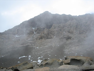
Much to our dismay, just as we were about to start the last leg of the climb (up the snow pack on the LaCroix Glacier to the final ridge) the weather suddenly changed, as it is wont to do. We had been seeing whispy cirrus clouds coming through, but the skies had remained blue. When we finished our break, though, the skies had turned to grey and it had started to snow! We waited a while to see if the weather would break and we could continue on, but to no avail. The temperature had dropped ~10oC easily and the cold forced us back down.

75% of the climb was an accomplishment, as most don't even try it. It just gives me (another) reason to come back.

The last day of our adventure, we got a very late start, though it was purposeful this time. We were both a little dehydrated and fatigued from three solid days of hiking (not to mention the epic mountain climb from the day before).

Luckily, the hike back to Lake Hoare was the "low route" along the valley floor. The only uphill we saw were in the form of short, rolling hills. We followed the Priscu Stream that ends at the eastern end of Lake Bonney.

The hike was beautiful, especially once the weather began to clear. Sandra and I were definitely a little fatigued during it, so it was nice for a leisurely hike back home. We were looking forward to sleeping in our own tents and eating with our field/trail family.

Other than my sampling, our other objective during this hike was to locate as many mummified seals as we could. A team will be coming in January that is trying to date the seals, but they don't have helo hours -- so seals within a day hike of Lake Hoare camp are preferred.


Probably my favorite area I've visited so far in the Valleys is known as the Defile. It is the narrow area between the Suess Glacier and the Nussbaum Riegel that acts as a wind funnel and large-scale sediment trap. So not only is the area beautiful, but it's also incredibly useful for my research.

The Defile was also the last bit of hiking before we entered the Lake Hoare basin (and a subsequent ATV ride back to camp for the exhausted hikers!)

The Lake Bonney experience was definitely a fun one, but it was good to be back home.