


December 1-4, Sandra (Lake Hoare's assistant camp manager) and I headed upvalley into the Lake Bonney basin. We dropped our sleepkits off at the camp itself, and got a ride back to the Marr Glacier and Upland Ponds area to sample. (Above left, the Marr and a pond; above right Bonney basin; left, Taylor glacier and a ventifact)
The area is very picturesque. The Marr feeds five ponds in an upland plateau that then drain down into the Hoare basin.
As we continued out of the upland area into the Bonney basin proper, we started encountering large-scale ventifacts that are a stark reminder of the power of the winds that whip through the valleys. The ventifacts are formed when the strong winds blow sediment and abraid away parts of the rocks. If enough of a catchment is formed, sediments can get caught inside and blown around to create bowls and other hollows.
On the second day, we headed out onto the lake itself. Lake Bonney is divided into two lobes

divided by the Bonney Riegel, which creates a "Narrows" separating the lobes (see left).
The western lobe terminates (or, technically, is fed by) the Taylor Glacier. The Taylor Glacier is home to another Special Feature: Blood Falls. Blood Falls is thought to be an ancient sea that was incorporated into the glacier. It is a major source of nutrients in Lake Bonney. When it's flowing, it looks like the glacier is bleeding, but since it wasn't, my pictures just looks like a large mud stain.
We continued up from the lake onto the Riegel and back to the western side of the Hughes Glacier to the other part of the ventifact fields. These were even larger scale than before, as noted by the fact that I actually was able to catch a nap in one.


After some setbacks on day three that gave us a late start, Sandra and I decided to hike the Matterhorn -- one of the tallest peaks (~2000m) in the valley.

The hike started out with beautiful weather and an initial three hour push up a scree slope. Most of the time the scree was just at it's angle of repose -- the point at which they can no longer maintain stability. It was frustrating to say the least. But onward and up!
Then we hit the area with exposed bedrock, which was much easier to climb though steeper. Another hour got us to a rolling plateau covered in red scoria cinders and granitic ventifacts, which made for an interesting contrast in colors (below left).

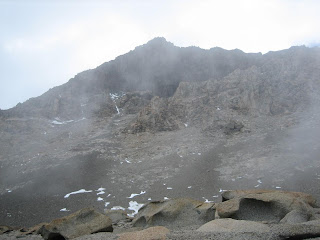
Much to our dismay, just as we were about to start the last leg of the climb (up the snow pack on the LaCroix Glacier to the final ridge) the weather suddenly changed, as it is wont to do. We had been seeing whispy cirrus clouds coming through, but the skies had remained blue. When we finished our break, though, the skies had turned to grey and it had started to snow! We waited a while to see if the weather would break and we could continue on, but to no avail. The temperature had dropped ~10
oC easily and the cold forced us back down.
75% of the climb was an accomplishment, as most don't even try it. It just gives me (another) reason to come back.
The last day of our adventure, we got a very late start, though it was purposeful this time. We were both a little dehydrated and fatigued from three solid days of hiking (not to mention the epic mountain climb from the day before).
Luckily, the hike back to Lake Hoare was the "low route" along the valley floor. The only uphill we saw were in the form of short, rolling hills. We followed the Priscu Stream that ends at the eastern end of Lake Bonney.
The hike was beautiful, especially once the weather began to clear. Sandra and I were definitely a little fatigued during it, so it was nice for a leisurely hike back home. We were looking forward to sleeping in our own tents and eating with our field/trail family.
Other than my sampling, our other objective during this hike was to locate as many mummified seals as we could. A team will be coming in January that is trying to date the seals, but they don't have helo hours -- so seals within a day hike of Lake Hoare camp are preferred.

Probably my favorite area I've visited so far in the Valleys is known as the Defile. It is the narrow area between the Suess Glacier and the Nussbaum Riegel that acts as a wind funnel and large-scale sediment trap. So not only is the area beautiful, but it's also incredibly useful for my research.
The Defile was also the last bit of hiking before we entered the Lake Hoare basin (and a subsequent ATV ride back to camp for the exhausted hikers!)
The Lake Bonney experience was definitely a fun one, but it was good to be back home.
 After leaving the Valleys, I had some time to kill in McMurdo. While dealing with drying out my samples, an ordeal that was more complicated than it sounds, I also did some walking. My friend, Nick (one of the firefighters), got a page about the possibility of penguins out at Hut Point. By the time we got there, the penguins had moved on but there were a couple of lethargic seals laying on the sea ice.
  I was supposed to leave the ice on December 16, but the flight was delayed in Christchurch. At 3:30AM on December 17, we were transported out to the Pegasus sea ice runway to catch our flight off -- a South African C100, which made for quite the ride. Cramped seats, leaking pipes, windows and all. All told, it took about 7 hours and we cleared customs faster than I ever have, with the exception of coming back from the Bahamas.


